Satellite images have revealed the scale of two wildfires spreading in southern California.
The Sandy Fire ignited on Monday morning in the city of Simi Valley, north-west of Los Angeles, according to California Governor Gavin Newsom.
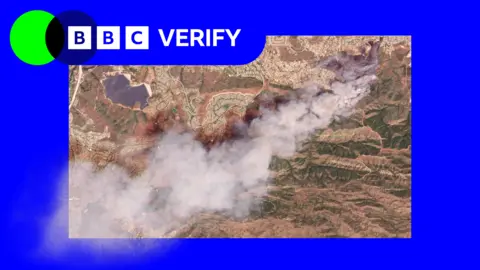
Satellite images taken just after noon local time (20:00 BST) on Monday show a large plume of smoke rising into the air just south of the city.
California fire officials said on Tuesday morning that 750 firefighters were being supported by night-flying water dropping helicopters to target hotspots.
The Simi Valley Police Department reported that an individual hit a rock with a tractor, which sparked the fire, as it spread across 1,364 acres (550 hectares) with no containment as of yet.
More than 10,000 homes have been evacuated from Simi Valley and surrounding communities, with a further 3,500 under evacuation warnings extending into neighboring Los Angeles County.
Los Angeles Mayor Karen Bass assured that officials don't expect the blaze to reach the city but have issued warnings as a precaution.
The situation has been further complicated by another fire on Santa Rosa Island, which has burned 14,600 acres (6,000 hectares) of the Channel Islands National Park, with the blaze uncontained and efforts ongoing.
Officials are closely monitoring the wildfires as they develop, utilizing NASA's satellite-based wildfire monitoring platform to assess hotspots and changes in fire movement.